

Silky white sand, luxurious resorts, and cloud-free weather all contribute to the perfect beach day. But for pure visual appeal, nothing is prettier than a beach with crystal-clear, ultra-blue waters. You’ll often find these peaceful stretches of sand in protected coves, where calm surf invites visitors to swim, snorkel, or commune with local marine life. With water ranging in shades from pale turquoise to deep cerulean, these beaches are nearly as dazzling as they are relaxing.
Anse Source d’Argent, Seychelles
- Location: La Digue | Google Maps
- Where to stay: La Domaine de L’Orangeraie Resort & Spa
La Digue, one of 115 islands in the Seychelles archipelago, is home to this impossibly scenic white-sand beach, which pairs gently lapping waves with sky-high palms and a cluster of smooth granite boulders that look a bit like a family of huddling elephants. Visitors access the beach by walking through L’Union Estate, a former French colonial coconut and vanilla plantation, and there’s a nearby beach bar selling tropical fruits, juices, and shakes. Bird-watchers flock here to spot Seychelles blue pigeons and an endemic species of paradise flycatcher, but the most magical way to explore these waters and the teeming coral reefs below the surface is by taking a three-hour guided tour in a transparent kayak with Crystal Water Kayaks.

Navagio Beach on the island of Zakynthos takes its name from the Greek word for “shipwreck.”
Courtesy of Andrey Shevard/Unsplash
Navagio Beach, Greece
- Location: Zakynthos, Ionian Islands, Greece | Google Maps
- Where to stay: Lesante Cape Resort & Villas
Part of the less-touristed Ionian islands chain off Greece’s western coast, Zakynthos is ringed with dramatic coves and sea caves. None can match the grandeur of Navagio (or Shipwreck) Beach; it’s hemmed in by towering limestone cliffs and named for the hulking wreck of the Panagiotis, which ran aground here in 1980. Mystery surrounds its final days, but according to legend, the ship faltered while being chased by naval authorities for smuggling contraband cigarettes. However the Panagiotis ended up here, its remains create especially cinematic photographs against the azure Ionian Sea—and its use as a filming location in the Korean drama Descendants of the Sun has made it a favorite among Asian tourists. While you can visit on a guided boat tour, the grandest way to take in the scene is from the cliff-top viewing platform.

The water at Trunk Bay is so clear that the park service has even installed an underwater marked snorkeling trail.
Courtesy of Josh Duncan/Unsplash
Trunk Bay, U.S. Virgin Islands
- Location: St. John, U.S. Virgin Islands | Google Maps
- Where to stay: Lovango Resort & Beach Club
Sixty percent of the Caribbean island of St. John is covered by Virgin Islands National Park, which was created when philanthropist Laurance Rockefeller donated his land to the federal government so it could be preserved in perpetuity. Among the most untouched beaches in the area is Trunk Bay, which takes its name from the local word for leatherback turtles. Visitors pay $5 per person to access this simple crescent of white sand backed by a wall of palms and sea grapes. The aquamarine water is so clear, it hosts an underwater trail with interpretive signs introducing snorkelers to local marine life, such as parrotfish, trunkfish, and brain coral.
Related: The Ultimate Beach Packing List for a Weeklong Vacation

The bright blue water of Gardner Bay makes for an excellent backdrop for Galápagos sea lion portraits.
Photo by Boyd Hendrikse/Shutterstock
Gardner Bay, Ecuador
- Location: Isla Española, Galápagos Islands, Ecuador | Google Maps
- Where to stay: Hotel Indigo Galápagos
Española is the southernmost of the Galápagos chain, and although the island is rugged and remote, that’s a big part of its charm. There are no hotels here, so you’ll have to stay on nearby San Cristóbal, and most day-trippers make a stop at Gardner Bay, a pristine, coral-sand beach populated by a colony of sea lions. The playful animals will often join swimmers and snorkelers in the surf, and because the water is gin-clear, you can watch their aquatic acrobatics underwater. Equally inquisitive are the endemic Hood mockingbirds that live on shore. They’re so fearless around humans, they’ll often land on visitors’ heads or shoulders in search of a snack.

The sand on Whitehaven Beach is almost purely silica, giving it a soft, cool texture and bright-white appearance.
Courtesy of Zhimai Zhang/Unsplash
Whitehaven Beach, Australia
- Location: Whitsunday Island, Queensland, Australia | Google Maps
- Where to stay: Qualia
About 550 miles north of Brisbane, the Whitsundays are a 74-island archipelago beloved by recreational sailors. The turquoise waters of Whitehaven Beach are rendered even more dramatic against the bone-white sand, which is more than 98 percent silica, or eroded quartz. The quartz’s presence is a geological mystery because the mineral isn’t found in these parts. The resulting sand is powder-soft and cool to the touch, and it was called “whispering sand” by the Indigenous Ngaro people due to the way it squeaks underfoot. While here, you may encounter baby lemon sharks, blue soldier crabs, goannas, and white-bellied sea eagles. You can camp on the beach’s southern end, although most travelers stay on the mainland in Airlie Beach or on neighboring Hamilton Island, and then access Whitehaven for a day trip by seaplane, helicopter, jet boat, or even a privately chartered yacht.

The karst limestone cliffs behind Railay Beach are popular among rock climbers.
Courtesy of Rachael Annabelle/Unsplash
Railay Beach, Thailand
- Location: Krabi Province, Thailand | Google Maps
- Where to stay: Rayavadee
Although part of the Thai mainland, Railay Beach is sometimes mistaken for an island because it’s cut off from its surroundings by impenetrable karst limestone cliffs and dense mangrove forests. You can only access this protected bay by catching a long-tail boat in Ao Nang (about 100 baht/US$3 per person each way). When you arrive, you may spot rock climbers tackling the cliffs, but you’ll be excused if you want to simply enjoy the clear water. From here, you can wander into town for a seafood lunch and then continue on to Phra Nang Cave, a shrine filled with wooden phalluses left by local sailors among the stalactites and stalagmites for the eponymous princess goddess.

The waters off of Lanikai Beach are a favorite feeding ground of green sea turtles.
Courtesy of John Ko/Unsplash
Lanikai Beach, Hawai‘i
- Location: Kailua, O‘ahu, Hawai’i | Google Maps
- Where to stay: Waimanalo Beach Cottages
This white-sand beach is hidden behind a residential neighborhood on O‘ahu’s quieter Windward Coast, but don’t assume it’s private property: All beaches in the state are open to the public, and you can reach this one via a series of narrow access paths. During the 1920s, developer Charles Frazier came up with the name Lanikai, which he thought meant “heavenly sea,” but he was wrong, and it means nothing in Hawaiian (the area’s original name was Kaʻōhao.) Looking out over the green-blue water, you’ll see Nā Mokulua, or “the Mokes,” a pair of islets you can explore by kayak. On a guided paddling trip with Kailua Beach Adventures, you’ll glide through sea turtle feeding grounds, over coral reefs, and past a seabird sanctuary that’s home to wedge-tailed shearwaters.
Related: 6 Must-Haves to Keep Your Valuables Safe on the Beach
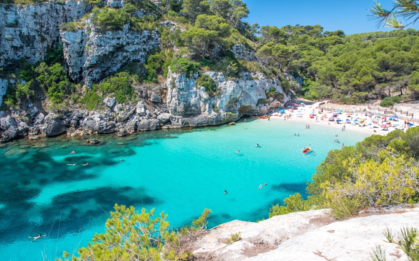
Cala Macarelleta is one of many secluded coves along the southern shore of Menorca.
Photo by Jacinto Marabel Romo/Shutterstock
Cala Macarelleta, Spain
- Location: Menorca, Balearic Islands, Spain | Google Maps
- Where to stay: Meliá Cala Galdana
Menorca, Mallorca’s laid-back little sister, boasts a coastline dotted with serene coves like Cala Macarella. It’s such an iconic beach that it often makes its way onto travel brochures and postcards. But if you want a calmer, quieter experience, stroll five minutes farther down the coast to Cala Macarelleta, where the water is strikingly blue. One of the coolest ways to take in the scenery from above is on the Camí de Cavalls (Path of Horses), a 116-mile trail for walking, mountain biking, and horseback riding that used to connect coastal watchtowers and fortresses and may date back as far as the 1300s.
This article was originally published in 2024 and most recently updated on January 13, 2025, with current information.


